Monday, May 30, 2016

Final Hazards Report

Reflecting back on this semester I have learned a lot of different hazards that the country of Thailand experiences. Thailand is a country located on the Indochinese peninsula in Southeast Asia with a population of approximately 66 million people. The weather is diverse across the country but mainly tropical. I had the pleasure of going to Thailand in Spring of 2014, it was a very beautiful country and I visited Chiang Mai, Bangkok and Phuket. These cities are all very diverse, Chiang Mai is in the jungle, Bangkok is the capital of Thailand and is a very large and industrialized city, and Phuket is a beach resort town. The two most dangerous natural hazards that Thailand experiences are earthquakes and flooding. 


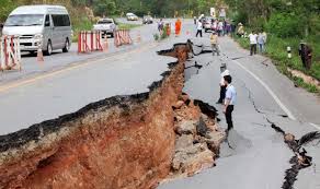
Earthquakes are very prevalent Thailand consists of 15 active fault zones (Department). The three biggest faults are the Pagoda and are located in central Thailand. “When a fault ruptures, rocks break apart suddenly and violently, releasing energy in the form of seismic waves. These waves radiate outward in all directions from the focus"(Keller 61). Earthquakes kill hundreds of people a year from  building collapses, falling objects, roadways splitting, bridges breaking, and objects falling atop people. This devastates the economy because it costs a lot in damage repair. Thailand has a pretty advanced warning system but it could be improved. I recommend creating a better evacuation plan and community efforts with making set plans for each town. This includes creating a food storage with foods that do not expire that can be taken on the go along with water bottles. 

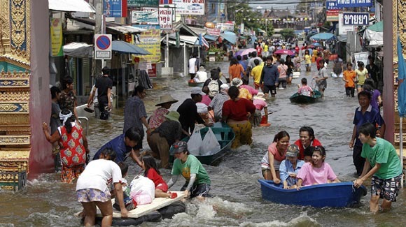
Flooding affects thousands of families each time it occurs in Thailand. This leaves many homeless and frantic to find food and shelter for the coming nights. This not only affects the immediate home owners but the farmers. Flooding kills crops by over watering and by bringing all the debris in the land around and it sits on the crops and makes and environment they cannot thrive in.  and creates an enormous amount of money losses yearly. It not only kills crops but people and animals too. Thousands of people get swept up in the currents and drown. Thailand runs off of tourism and with natural disasters occurring repeatedly it creates a decline in visitors. I recommend satellite imagery of floods that can predict and help countries cope with floods. This allows for families to evacuate and get all belongings out of the area before the disaster strikes. 


I would target the northwest areas of the country for flooding and central Thailand for earthquakes. If I were to build a house I would build it in the southwest, this is on the beach and it experiences some natural disasters but more of the tropical storms. This is the most beautiful area in my opinion. 

Sources:
Keller, Edward A., Duane E. DeVecchio, and Robert H. Blodgett. Natural Hazards: Earth's Processes as Hazards, Disasters, and Catastrophes. Upper Saddle River, NJ: Pearson Prentice Hall, 2012. Print.
http://earthquake.usgs.gov/hazards/about/workshops/thailand/downloads/Thailand-workshop-results-new.pdf
http://www.dmr.go.th/main.php?filename=fault_en
http://www.livingthai.org/earthquakes-in-thailand.html
http://www.seismology.tmd.go.th/en/
http://floodlist.com/asia/thailand-floods-over-3000-families-affected-in-northern-provinces
http://floodlist.com/asia/4-dead-14000-evacuated-floods-thailand-malaysia-border
http://floodlist.com/asia/flood-resistant-rice-tested-thailand
http://floodlist.com/asia/servir-mekong-satellite-maps-flood-protection-se-asia
http://floodlist.com/protection/targeted-tree-planting-alleviates-flooding
http://www.floodsafety.noaa.gov/during.shtml

Picture Sources:
http://www.bbc.co.uk/news/world-asia-15581957
http://earthquake-report.com/2011/03/26/massive-and-extremely-dangerous-earthquake-in-the-border-area-in-between-myanmar-thailand-laos-and-china/
http://www.thaisocal.org/2011/10/19/the-thai-association-of-washington-state-tawa-to-act-as-a-primary-contact-for-thailand-flood-victim-donation/

Friday, May 6, 2016

Week 13: Coastal Erosion

Thailand’s coastal erosion is prominent. "The exploitation of resources, population growth, developments of tourism, aquaculture, and industries caused evidences of environmental degradation in resources of the areas that lead to coastal problems” (Department of Mineral Resources). Thailand has a total coastal length of 2,815 km that consists of sandy beaches, dunes, wetland, rocky coast, cliffs and islands. 


Coastal erosion can be solved with technologies and management. The main reason these problems have not been solved as of yet is the overlapping responsibilities among government agencies. There is conflict on the issues. With the main problems being development and tourism (littering) this could be solved by not creating new attractions or at a slower rate. Rising sea levels due to climate change are also a big threat to Thailand’s coast line. Local residents depending on fishing will be at risk. Sandbags are placed offshore to help slow down erosion and dissipate the powerful waves while trapping sediment to protect mangrove forest growth. The Thai government alerts the coastal areas by using radio and tv frequencies along with newspaper articles explaining that the coastal areas are due to erosion. Buying land on the coast is not encouraged at least in the places prone to cliff erosion. The Thai weather and geological center monitors the erosion and is in action to prevent further damage. 

Sources:
http://www.dmr.go.th/main.php?filename=coastal_En
http://www.irinnews.org/report/79685/thailand-sustainable-approach-tackle-coastal-erosion

Picture Source:
http://www.phuketgazette.net/thailand-news/Phuket-Gazette-Thailand-News-Andaman-erosion-avian-flu-alert-Poh-pardon-polls-to-please/20146
http://paranormalis.com/threads/loss-of-life-from-landslides.4161/
http://wwwnc.cdc.gov/travel/yellowbook/2016/select-destinations/thailand

Friday, April 15, 2016

Week 10: Extreme Weather

Like most countries, Thailand faces extreme weather conditions every year. Flooding is the biggest threat to Thailand's people and economy. The monsoonal rains in 2011 season alone killed 437 people and affected at least 2 million. What I found interesting about Thailand's weather is that snow does not exist there. The closest it has to snow is hail, one year people reported it to be snowing but it was actually small pieces of hail. Basically, rain is the biggest threat to Thailand, it can persist in some areas for months at a time with hardly a break in between rainfall. Climate change is going to have an huge impact on the severity of storms in the coming years, as it has been increasing immensely in the last 10 years.

Sources:
http://earthsky.org/earth/extreme-flooding-in-bangkok-thailand
http://www.mowe-it.eu/wordpress/thailands-strategy/
http://www.theguardian.com/environment/2011/nov/18/extreme-weather-climate-change-ipcc

Picture Source:
http://www.forbes.com/sites/mindylubber/2011/11/23/ipcc-report-confirms-what-businesses-already-know-extreme-weather-climate-change-has-economic-impacts/#5934233858e5

Thursday, March 24, 2016

Week 8: Mass Wasting Hazards

Landslides are one of the biggest threats to Thailand's people and property. Thailand is susceptible to this major natural disaster USUALLY due to the heavy rains. It is mainly a hazard to the northwestern and southern regions where the most flooding occurs. In an article I was reading it stated that "The landslides occurred because of unseasonably heavy rain, during which more than 1,200 millimeters (47 inches) fell. The ensuing floods and landslides affected more than two million people and killed 53 in 11 Thai provinces, said news reports on April 5"(Earth Observatory). In another article it stated a bunch of ways that the country prevents and helps the people in affected areas. A couple ways is that people in the vulnerable areas join together as a community and plan what will happen incase of the emergency situation. DMR has been working on creating a disaster warning signal that can be sent to others and evacuations can take place easier (DMR). The DMR checks vulnerable areas regularly to test out the soil and other factors. With the communities working together to create a safer and well planned out disaster program. Below are a few photos of previous landslides in Thailand:


sources:
http://landslides.usgs.gov/learn/prepare.php
http://earthobservatory.nasa.gov/IOTD/view.php?id=49976
http://www.dmr.go.th/main.php?filename=landslide_En

Picture sources:
http://blogs.agu.org/landslideblog/2011/04/01/large-landslide-in-thailand/
http://poleshift.ning.com/profiles/blogs/thailand-vietnam-landslide-blocks-railroad-in-north-quakes-with

Sunday, February 28, 2016

Week 5: Volcanic Activity

Thailand has 2 volcanos Doi Pha Khok Hin Fu, and Phanom Rung. Although, both are extinct and Phanom Rung actually has a temple built on top of it. (pictured below)


 The closest active volcanoes to Thailand is the Barren Island Volcano and the Sinabung Volcano. The Barren is a stratovolcano has minor activity or eruption warning located in the Andaman Sea. It was last updated Feb 3, 2016 with weak thermal hot spot. The Sinabung is a stratovolcano and was last updated Feb 23 2016 as erupting (continuing pyroclastic flows). On February 2, 2014 "At least 16 people were killed when an Indonesian volcano (Sinabung) that had been rumbling for months unleashed a major eruption." These volcanoes can evoke deadly lava, gases, and ash when erupted. 

(Barren Island Volcano)


(Sinabung Volcano)


Thailand is very developed compared to some of it’s neighboring countries and has established a warning system. “Thailand: the Thai Meteorological Department provides updated storm warnings, not just for the country, but for the rest of Southeast Asia as well. Thailand weather varies from north to south, so don't assume the weather is the same from one point of the country to the next.” This center is designed to regulate warnings to other countries about volcanic, seismic, and other activity present. Since there are no active volcanos in Thailand the people there don't necessarily have to worry. 


Sources:
http://www.scmp.com/news/asia/article/1418876/least-16-dead-after-indonesian-volcano-mount-sinabung-erupts

Picture sources:
http://www.thaifoodandtravel.com/travel/itind.html
http://www.andamanmangroves.com/InBarren.php
http://www.scmp.com/news/asia/article/1418876/least-16-dead-after-indonesian-volcano-mount-sinabung-erupts
http://guardianlv.com/2013/11/mount-sinabung-volcano-erupts-again-thousands-flee-crops-destroyed/

Thursday, February 18, 2016

Week 3: Seismic Activity

Thailand consists of 15 active fault zones (Department). The three Pagoda faults are the biggest threat to central Thailand. There is shallow seismicity in northern Thailand(USGS). Earthquakes rarely occur and if they do they are small scale. "When a fault ruptures, rocks break apart suddenly and violently, releasing energy in the form of seismic waves. These waves radiate outward in all directions from the focus"(Keller 61).


One of the worst earthquakes in Thailand's history was that of Myanmar in 2014. It was a 6.3 and located near a northern city Chiang Mai, with 1 killed and 20 injured (Travelers Today). It left roads cracked and structures broken. Although, technically the epicenter was in Myanmar in Burma and a 6.8, it is so close to Thailand's border that it was felt all the way down in Bangkok the Capital city. 
 

According to Livingthai.org, if a 7.0 earthquake were to occur it would completely flatten Thai structures and the country runs off of tourism. This kind of seismic activity would greatly hurt the countries economy(Living Thai).
 As for a warning system the "Thai Meteorological Department established an Automatic Earthquake Monitoring System to serve all the need of raw ground motion data, sea level changes, displacement and analyzed seismic data for the public interest and multi users. The system consists of 40 seismic stations, 26 accelerograph stations, 9 tidal gauge stations, 4 GPS stations. The operational works are 24/7 basis to continuously monitor, watch and disseminate of relevant information, messages and warning regarding to earthquake and tsunami hazard" (Seismology). This will provide a sense of security and somewhat of a quick response warning that will be sent out so people can prepare and move east or high ground in case of tsunamis.


Sources:
Keller, Edward A., Duane E. DeVecchio, and Robert H. Blodgett. Natural Hazards: Earth's Processes as Hazards, Disasters, and Catastrophes. Upper Saddle River, NJ: Pearson Prentice Hall, 2012. Print.
http://earthquake.usgs.gov/hazards/about/workshops/thailand/downloads/Thailand-workshop-results-new.pdf
http://www.dmr.go.th/main.php?filename=fault_en
http://www.livingthai.org/earthquakes-in-thailand.html
http://www.seismology.tmd.go.th/en/


Picture Sources:
http://www.dmr.go.th/main.php?filename=fault_en
http://www.travelerstoday.com/articles/9742/20140506/thailand-earthquake-today-magnitude-6-3-photos-devastates-myanmar-northern.htm
http://www.livingthai.org/earthquakes-in-thailand.html


Friday, February 12, 2016

Week 2: Plate Tectonics


Thailand is located on the Eurasian plate boundary. The plates coming together around Thailand have many different boundary types. If only it were so simple! It looks like the mass of Thailand is on two different blocks which are attached to the Eurasian plate which Asia sits on. To the southwest of Thailand, the plate is subducting ocean floor (line with little triangles). Those other lines on the map mostly look like transform faults (Plates and faults are often confused. Faults are mini versions of plate boundaries; much shallower). Divergent boundaries really only occur on the deep seafloor as it spreads apart and spits out basalt.
Thailand is on the Eurasian plate but it also is in the region of the Sunda Plate. "The Sunda Plate was formerly considered a part of the Eurasian Plate, but GPS measurements have confirmed its independent movement at 10 mm/yr eastward relative to Eurasia"(Wiki). Thailand is not located on a fault line so it rarely experiences earthquakes. The eastern region is completely in green meaning that it is completely safe. "Thailand has a number of active faults with the potential to trigger tremors, many of which are concentrated in the northern and western regions. However, these faults do not have the capability to cause strong quakes like those in the Ring of Fire or in areas directly on top of tectonic plate boundaries"(Chula).


Sources:
http://www.cicc.chula.ac.th/en/2012-04-26-04-31-26/203-likelihood-of-earthquakes-in-thailand.html
https://en.wikipedia.org/wiki/Sunda_Plate

Picture Source:
http://mpconline.mpc.edu/pluginfile.php/429774/mod_resource/content/1/Summary%20PlatesBoundaries.pdf
https://en.wikipedia.org/wiki/Sunda_Plate
https://www.e-education.psu.edu/earth520/content/l2_p14.html

Friday, February 5, 2016

Week 1: Hazards, Disasters, and Catastrophes

My country is Thailand


 If you visit Thailand you could experience tsunamis, floods, cyclones, and droughts. Thailand hardly experiences earthquakes, and doesn't have tornados or volcanic activity(Chiangmai Times). Thailand is known for having a tropical climate and high humidity. This means that during the rainy seasons it comes to be a problem when there is excess rain in the low laying plains causing floods. The two main disasters that occur in this region are Cyclones and Floods. "Flooding in Thailand during this year's monsoon season has killed more than 200 people and affected at least two million more"(Corben, 2011). 1904-2004 Thailand experienced 47 floods causing killing 2,427 people and affecting 27,193,357 lives (Center for Hazards).


The difference between Hazards, Disasters, and Catastrophes is always good to know when talking about different events. According Dr. Ana Garcia-Garcia, Hazards are natural processes or events that could potentially threaten human life or property. For example: 2015 Northern California wildfire.  Disasters are hazardous events that occur in a limited timeframe. Events are classified Disasters if one or more of these take place: 10 or more people are killed, 100 or more people are affected by the event, the country declares a state of emergency, or if they ask for international assistance. For example: 2010 Guatemala sinkhole killing 15 people. Lastly, Catastrophes is an event that takes place and destroys so much that it takes years and large amounts of money to recover from. For example: 2010 earthquake in Hati, which still hasn't fully recovered.  


Sources:
http://www.chiangraitimes.com/what-natural-disasters-could-you-experience-in-thailand.html
http://www.statravel.com/thailand-climate.htm
http://www.voanews.com/content/thailand--floods-worst-in-five-decades-130972153/146066.html
https://en.wikipedia.org/wiki/Natural_disaster
https://www.ldeo.columbia.edu/chrr/research/profiles/thailand.html

Picture Sources:
http://whotv.com/2014/11/18/americans-wanted-for-trying-to-ship-thai-infant-body-parts/
http://www.cbc.ca/strombo/news/new-report-says-many-of-the-worlds-natural-disasters-in-2011-were-the-worst